


National parks are part of the wealth we have. In the United States alone, the national park system covers more than 84 million acres in the 50 states, the District of Columbia and all territories of the country. Each park is of incomparable beauty and has a rich past. It is, therefore, worthwhile to explore the national parks. It must be said that the parks are also surprising from a spatial point of view. Read this article to see pictures of the parks seen over the planet Earth.
1. Zion National Park
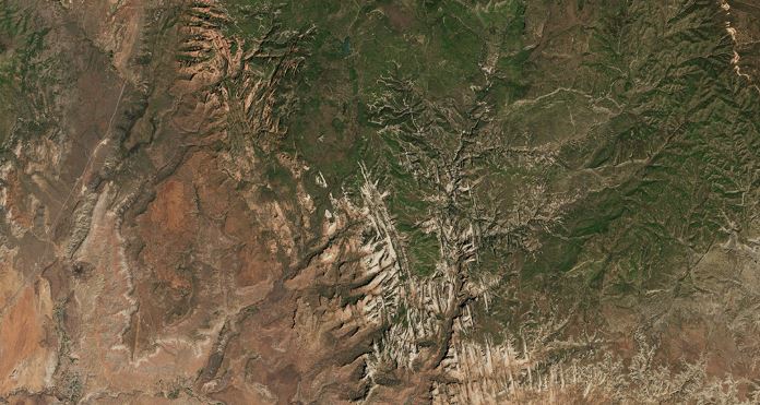
Zion National Park is a nature reserve in southwestern Utah that is characterized by the steep red cliffs of its canyon and extends over 229 square miles of semi-arid desert. The image was acquired by the Operational Land Imager (OLI) on Landsat 8 on June 1, 2016. Isn’t that impressive?
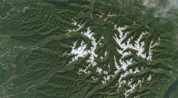
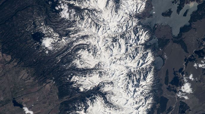
2. North Cascades National Park
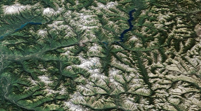
Despite its name, the most glaciated area of the contiguous United States is not Montana Glacier National Park. The distinction belongs to North Cascades National Park in Washington. The snow- and ice-covered mountains of the North Cascades are visible in this natural-color image acquired on September 13, 2016, by the Operational Land Imager (OLI) on Landsat 8, draped on field data from the Advanced Thermal Emission and Reflection Space Radiometer (ASTER).
3. Katmai National Park
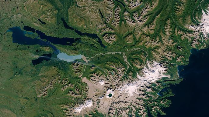
In 1912, magma flowed under Mount Katmai and exploded through the Novarupta volcano. Moving at a rate of 520 million tonnes per hour, the material ejected from this Alaskan volcano was 30 times more abundant than during the 1980 eruption of Mount St. Helena. The Katmai National Monument was erected by the American government in 1918 to protect this extreme volcanic landscape. The Landsat 8 satellite’s operational ground imager (OLI) acquired a natural-color image of the park on September 23, 2014.
4. Crater Lake National Park
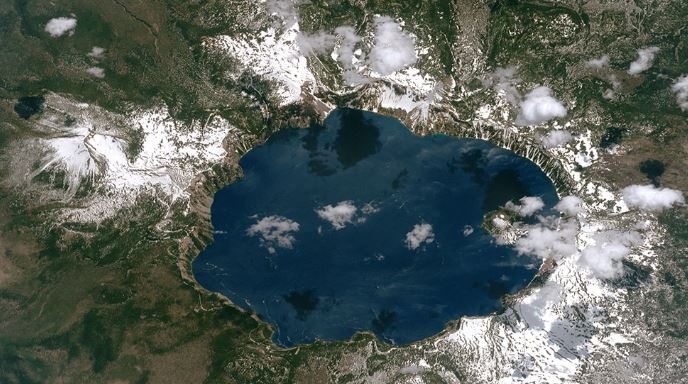
An astronaut onboard the International Space Station took this photograph of Crater Lake, in the Cascade Mountains, southwest of Oregon, on June 26, 2017. It is hard not to be overwhelmed by the beauty of this landscape!
5. Biscayne National Park
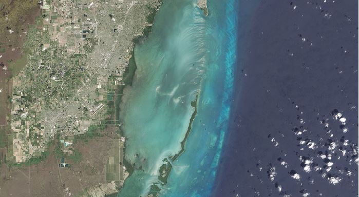
Many U.S. national parks can be visited by taking scenic roads or hiking trails. Visit Biscayne National Park in South Florida, however, and you may want to explore it by boat. 95% of this park is underwater. The park encompasses the northernmost Florida Keys, from Miami to north of Key Largo.
6. Apostle Islands National Lakeshore Lake
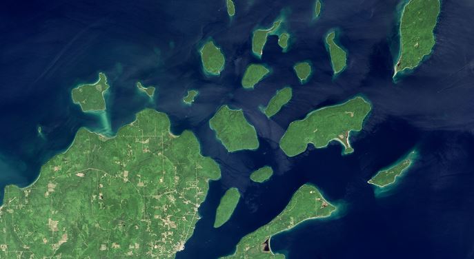
Apostle Islands National Lakeshore Lake consists of 21 islands and a strip of continental land at the top of Wisconsin. Management of the islands by the National Park Service (NPS) began in September 1970. There are more lighthouses in this park than in any other NPS property.
7. Denali National Park

Featuring North America’s highest mountain, Mount McKinley, 20,320 feet high, Denali National Park includes more than 6 million acres of diverse ecosystems, mountains, and glaciers.
8. Bryce Canyon National Park
On March 9, 2017, Landsat 8’s Operational Land Imager (OLI) captured this natural-color image of Bryce Canyon National Park. Unlike canyons carved mainly by a river, Bryce Canyon is the result of erosion caused by time. In fact, over the years, bad weather has shaped this magnificent landscape.
9. Olympic National Park
It must be one of the most diverse national park landscapes in America. If you walk from west to east through the Olympic National Park, you would cross the rocky shore of the Pacific, move through rare temperate rainforests and lush river valleys, climb glaciers and rugged mountain peaks, and then descend into an alpine forest. From the beach to the top of Mount Olympus, you would rise 2430 meters above sea level. The park covers nearly 923,000 acres of wilderness, including 60 named glaciers, 73 miles of coastline and 3,000 miles of rivers and streams.
10. Grand Canyon in Arizona
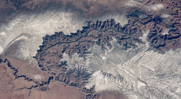
Here is a rather impressive picture of the Grand Canyon in Arizona from the Space Shuttle Discovery during NASA’s STS-60 mission in February 1994. That’s different from the pictures we’re used to seeing on Instagram, isn’t it?
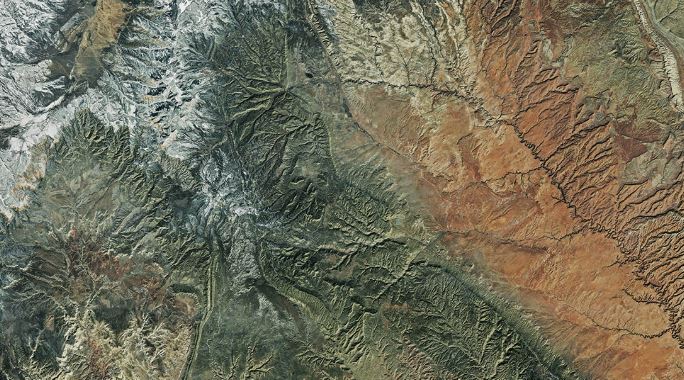
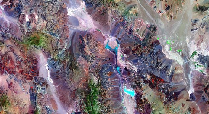
11. Great Sand Dunes National Park

Great Sand Dunes National Park in southern Colorado contains more than sand – the 84,670-acre park also includes mountains and tundra, pine and spruce forests, aspen forests, grasslands, and wetlands – in short, an extremely diverse landscape! This natural-color image was acquired by Landsat’s Thematic Mapper plus (EMT+) tool on October 14, 1999.
12. Shenandoah National Park
On July 3, 1936, President Franklin Delano Roosevelt stood among the crowd at Big Meadows and officially opened Shenandoah National Park in Virginia. The long and narrow Blue Ridge Mountains Park extends over 179,000 acres, 40% of which is protected in the wild. More than 95% of the park is wooded, with 1,300 plant species and 267 tree and shrub species. The park contains 577 archaeological sites, more than 100 cemeteries and rocks that date back a billion years. The Landsat satellite thematic cartographer captured this view of Shenandoah National Park on October 10, 2010.
13. Glacier National Park

Taken by Jeff Williams of NASA from a low Earth orbit on the International Space Station, this blue photo represents Glacier National Park.
14. Grand Teton National Park
NASA astronaut Jeff Williams captured a series of images of Grand Teton National Park, assembled in this composite, during his Expedition 48 mission aboard the International Space Station.
15. The Valley of Death
At 282 feet below sea level, California’s Valley of Death is one of the warmest and driest places on the planet. On average, the region receives only 1.96 inches of rain per year, and summer temperatures regularly exceed 100 degrees Fahrenheit. At night, temperatures drop considerably. The plants and animals that live in this challenging environment have had to adapt to the extreme temperatures and aridity of this climate. This amazing image was compiled from observations made by the Enhanced Thematic Mapper Plus sensor on the Landsat 7 satellite on June 11 and July 20, 2000.


